History
All heathland part of the primeral forests – Neolithic man commenced clearance.
500 BC The very presence of heathland indicates Bronze Age man clearing the pre-historic forest for the farming. In turn these bare, sandy, porous soils leach out all nutrients forming heaths. Man inadvertently maintains these heaths via grazing, burning and harvesting.
 1611 John Speed’s Tudor Atlas records “the Dorsetshire heathlands in the vicinity of Poole and Wareham yielding furze and ling for fuel that were economically important for the local community”. He refers to smugglers using the wilderness of the commons and heaths “Wherein they may travel within so to conceal their contraband”.
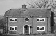
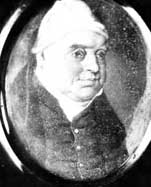
Isaac Gulliver (1745-1822) the celebrated smuggler of the Winborne area would have tramped across Slop Bog. He kept forty or fifty men constantly employed and these wore a kind of livery, powdered hair and smock frocks, from which they attained the name of “White Wigs”
Masterly organisation, quick wittedness and amazing daring enabled him to pull off one coup after another and to prevent the custom men from being able to arrest him or collect sufficient evidence to convict him. Slop Bog, lying beside Uddens Water would have been within an area of relatively fertile land and agriculture would have been the main employer. With a one night’s smuggling a farm labourer could earn the equivalent of an entire week’s wage – so there were plenty of volunteers! Gulliver was a notorious and very successful local smuggler who died in 1822 a wealthy man and is buried at Wimborne Minster. In his will, he left some £60,000, which today would be worth over £4 million. Gulliver’s Farm on the main road North of West Moors was once owned by him.
1759 Slop Bog is a small wet corner of Hampreston Heath, which itself is part of a massive heathland complex stretching to the coast.
1811 An OS map identifies the site as part of Uddens Heath. The Old Thatch Inn is the gatehouse to the Uddens Estate. The neighbouring land is referred to as Wool Bridge Heath.
1815 The Hampreston Enclosure Award shows local people possessing Turbary Rights for Slop Bog. This means that they are entitled to cut a small allotment of peat or heather turves that they then use as slow burning domestic fuel.
1847 The single line Southampton – Dorchester railway opened through West Moors with a “halt” at Ameysford. Soon after, Stewarts Nursery arrived and used the railway to send its mail order waterlillies grown on Slop Bog around the country.
1870 An OS map shows the site to be part of Beaufoys Plantation with much of drier heath lost to the conifer plantation. Another OS map identifies Slop Bog as being part of Hampreston Heath.
1902 The Uddens Estate is owned by the Greathead family and their Estate Register records a purchase of 320 fir trees for Beaufoys Plantation at a cost of £24. Today’s pines on Slop Bog would be the descendants of this planting.
 1915 An aerial photograph clearly shows the peat cuttings with the pine plantation on the drier ground. Stewarts Nursery is visible on the other side of West Moors Road. They cultivate water lilies and other aquatic plants for sale for the first ever mail order plant catalogue.
Pre 1930 Increasingly the surrounding land holdings are divided into smaller plots on which individual houses are developed. The suburban sprawl eats up the countryside.
1930 A Mr Joseph runs a nearby nudist colony !
1940s Soldiers based at West Moors are not unknown for their cars to come off the West Moors Road at the snake bends into the bog. The bends are allocated soldiers’ names in memory of their mishaps! A Typhoon bomber lands in Slop Bog and drifts, cockpit open and black peat flying, coming to a halt just before the West Moors Road.
1952 Jim Brown, an employee of Stewarts Nursery, works on lily ponds. He lives alongside Slop Bog in a timber bungalow made from three chicken sheds put together! Jim observes smooth snakes and water voles – the latter he believes to be eating the lily flower heads.
1969 An aerial photograph shows scattered pines are on the Southern end of the site. There is no thick woodland strip.
1970s A proposal is put forward to expand the housing development into Slop Bog and the bungalows in Hazel Drive are built. A shire horse becomes stuck within the bog needing the aid of a tractor to regain its freedom. An aerial photograph shows a new drainage ditch behind Hazel Drive feeding into the old peat cuttings. Vehicle tracks are shown to cross the heath and it is likely that dumping of at least one car occurred during this time. The bog shows little open water with the lily ponds clearly having been abandoned.
1984 The final phase of development on the edge of Slop Bog occurs with the construction of Cedar Way and Redwood Drive. The site undergoes an ecological Survey as part of Broad Moor Common prior to by-pass construction.
1985 With the construction of the Ferndown by-pass, Slop Bog becomes defined by its final boundaries. It is separated from Broad Moor common and bounded by housing, the by-pass and West Moors road.
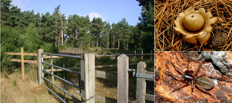
1986 – Present day: Slop Bog is declared a Site of Special Scientific Interest due to the plant and animal communities associated with this piece of bog and typical Dorset heathland. Together with the other remaining Dorset Heaths, Slop Bog is part of the 15% that remains of the Dorset Heaths of the 1850s. The site consists of dry, humid and wet heath, bog and wet woodland and coniferous plantation. Whilst the heathland supports a range of rare species, typical of Dorset, the bog is full of diversity in part due to the peat cuttings and pond digging. In particular, the site supports populations of Marsh Gentian (gentiana pneumonanthe), Bog Asphodel (narthecium ossifragum), Brown Beak Sedge (r.fusca), Mud Sedge (carex limosa), Bog Bean (menyathes trifoliate) along with some twelve species of dragonflies and damselflies – including the rare Small Red Damselfly.
1992 Dorset County Council purchase Slop Bog with the intention of creating a Local Nature Reserve. Around this time peat turves are cut and taken for the Natural History Museum to create a bog garden.
2002 On 3 December Slop Bog is declared a Local Nature Reserve by the landowners Dorset County Council.
![]() 2003 Innovative Pine clearance by Alaska Environmental using specialist excavators and a mobile incinerator.
2003 Innovative Pine clearance by Alaska Environmental using specialist excavators and a mobile incinerator.
2005 Installation of livestock fencing
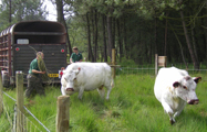
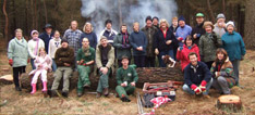
2006 Livestock commence grazing Slop Bog. The cows fulfill an important function in controlling grass and sapling growth thereby protecting the heathland habitat. In March the Natural History Museum came and took more specimen samples for their Bog Garden. Slop Bog volunteers win the East Dorset District Council’s Community Service Award. The Presentation Evening sees Chris Packham presenting the awards

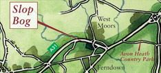
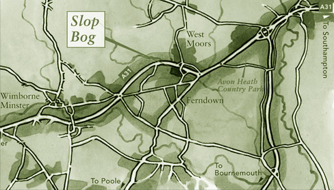
Where is Slop Bog?
Situated in Ferndown, Dorset - there are several entries to the nature reserve from the B3072 West Moors Road.
how to find us »
Get Involved?
If you would like to get involved with the work parties, then contact us here
Get Involved »